1/10
GeoEditor for MapTiler screenshot 0
GeoEditor for MapTiler screenshot 1
GeoEditor for MapTiler screenshot 2
GeoEditor for MapTiler screenshot 3
GeoEditor for MapTiler screenshot 4
GeoEditor for MapTiler screenshot 5
GeoEditor for MapTiler screenshot 6
GeoEditor for MapTiler screenshot 7
GeoEditor for MapTiler screenshot 8
GeoEditor for MapTiler screenshot 9
GeoEditor for MapTiler Icon

GeoEditor for MapTiler

Klokan Technologies GmbH
Trustable Ranking IconTrusted
1K+Downloads
28MBSize
Android Version Icon5.1+
Android Version
2.0.1(12-03-2020)Latest version
-
(0 Reviews)
Age ratingPEGI-3
How to install
1
Download and open the installation file
2
Unblock AptoideAptoide is a safe app! Just tap on More details and then on Install anyway.
3
Complete the installation and open Aptoide
app-card-icon
DetailsReviewsVersionsInfo
1/10

Description of GeoEditor for MapTiler

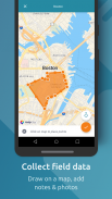
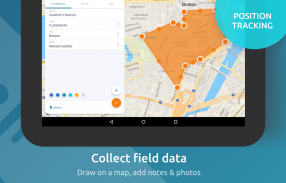
See your GPS position on your own maps. Draw points, polygons and lines on the maps. Collect field data and notes related to a location, attach a photo and fill custom attributes.


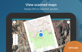
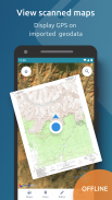
Display offline maps generated by MapTiler (http://www.maptiler.com).


The app supports GeoJSON and MBTiles formats and synchronization via Google Drive for basic sharing of the data with other people! Perfect for mobile data collection for GIS and surveys.


It is easy to import scanned hiking maps, PDF maps, drone aerial imagery, nautical charts for sailing and navigation with a boat or a yacht, fishing maps, aeronautical charts for flight planning by pilots, parcels and city plans and other opendata from local government. OpenStreetMap vector maps are powered by OpenMapTiles project (the successor of OSM2VectorTiles). Maps can come from existing tile servers with TileJSON or XYZ tiles.


Supported geodata formats by MapTiler: GeoTIFF, TIFF, JPEG, ECW, SID / MrSID, NOAA KAP / BSB, DEM, OziExplorer OZI OZF2 & OZFX3, WebP, JP2, JPEG2000, GeoJP2, Erdas, Grass, Safe, Sentinel2, SRTM, NASA imagery, USGS map sheets, exports from ESRI ArcGIS, ArcSDE, etc.


The GeoJSON can be converted from / to: ESRI ShapeFile, DXF, DWG, GPX, CSV and KML.


Contact us if you want to use the functionality from this app in a rebranded app for your customers, for your business use-case or for presenting your own maps. We can provide the source code and assist with customization.</br></br></br></br></br></br></br></br></br></br></br>

GeoEditor for MapTiler - Version 2.0.1

(12-03-2020)
Other versions
What's new- MapBox SDK updated to the latest version (iOS 3.5 - Android 5.0)- a new dialogue after map or data file import, to view the added content instantly- a new View action for all maps or data in the screen "Manage layers"- font updated to KlokanTech Noto, with improved support for Hebrew and Arabic labels- OpenStreetMap logo as a "thank you" to all OSM contributors- minor bug fixes, tweaks and improvements

There are no reviews or ratings yet! To leave the first one please

-
0 Reviews
5
4
3
2
1
Info Trust Icon
Good App GuaranteedThis app passed the security test for virus, malware and other malicious attacks and doesn't contain any threats.

GeoEditor for MapTiler - APK Information

APK Version: 2.0.1Package: com.maptiler.geoeditor
Android compatability: 5.1+ (Lollipop)
Developer:Klokan Technologies GmbHPrivacy Policy:https://www.maptiler.com/privacy-policyPermissions:13
Name: GeoEditor for MapTilerSize: 28 MBDownloads: 256Version : 2.0.1Release Date: 2020-03-12 19:20:28Min Screen: SMALLSupported CPU: x86, x86-64, armeabi-v7a, arm64-v8a, mips
Package ID: com.maptiler.geoeditorSHA1 Signature: 04:BA:05:B3:E2:F7:85:49:57:EF:D6:67:A8:88:6A:0E:8A:76:93:05Developer (CN): Organization (O): KlokantechLocal (L): Country (C): State/City (ST):

Latest Version of GeoEditor for MapTiler

2.0.1Trust Icon Versions
12/3/2020
256 downloads28 MB Size

Other versions

1.3.0Trust Icon Versions
28/5/2017
256 downloads25 MB Size

Apps in the same category

You may also like...